Cranberry Lake
BRIEF HISTORY OF CRANBERRY LAKE by Stephen Whitehead and Manuel Stevens
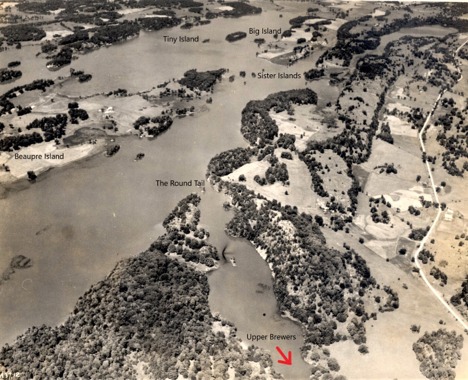
Cranberry Lake is without doubt a beautiful lake. It stretches from the Brass Point Bridge (where it connects to Little Cranberry Lake) to the Round Tail (where it joins the channel of the Rideau Canal leading to Upper Brewers lock) and to the narrow and perilous (to boaters who try to cut the angle) Fiddler’s Elbow (where it joins Dog Lake). The lake is navigable all the way around Beaupré Island, which serves as the centrepiece of the lake. The main channel of the Rideau Canal coming from Ottawa en route to Kingston runs from the Brass Point Bridge, past Track Island, in between Tiny and Big Islands north-east of Beaupré, and past the Sister Islands east of Beaupré before arriving at the Round Tail.
Robert Leggett in his classic work Rideau Waterway (2nd edition, 1986, University of Toronto Press) describes the view of Cranberry Lake as one travels from Highway 15 to the Brass Point Bridge:
The bridge is easily reached from [Highway 15] by a turn one mile south of Seeley’s Bay, and the road to it gives a glorious panoramic view of the full sweep of Cranberry Lake. I must confess that no view of the Waterway is so moving as this scene on a calm summer day, the blue waters of the lake fading into the distance beyond the wooded profile of Beaupré Island, with its attendant islets around …. For this is a man-made lake, one of the first so made in North America, dammed up after a fight in the wilderness against ravaging fever, the rigours of the Canadian winter, and almost unbelievable difficulties in construction. (at p. 127, emphasis added)
Leggett also notes that “Cranberry Lake is today a perfect example of Canada’s northern scenery.” (at p. 126)
All who delight in Cranberry Lake today must not forget that it did not exist in its current form until less than 200 years ago.
In 1800, Cranberry Lake was a very shallow small lake that was bounded by the northern point of Beaupré Island, the current western shore of the lake (the Burnt Hills area) and by a shore extending along a line between the current Big Island and Track Island. The location of the old Cranberry Lake is where the deepest parts of the new Cranberry Lake are found, and they are not very deep.
Old Cranberry Lake was a small part of a vast area, known as the Cranberry Flood Plain, extending from Deans Island (which was then part of the mainland) in what is now Whitefish Lake (near Jones Falls) to the Round Tail. The Cranberry Flood Plain was not navigable. It drained into the Cataraqui River at the Round Tail and ultimately into the Gananoque River through what is now known as Morton Bay and Morton Creek.
In about 1803, a sawmill and dam were constructed at Morton, which backed up into the Cranberry Flood Plain some of the water that would otherwise have drained into the Gananoque River. In subsequent years and prior to 1816, a dam was constructed at the Round Tail. According to Ken W. Watson, who has an excellent website devoted to the Rideau Canal - http://www.rideau-info.com/canal/index.html - and who has written a number of books about the Canal, this dam together with the dam at Morton raised the waters in the Flood Plain to a depth of about 6 feet. As noted by Watson:
This created the Drowned Lands, an area below Jones Falls containing acres and acres of dead standing (drowned) trees. It also made the Cranberry Flood Plain navigable by canoe for the first time, directly connecting the southern pre-canal Rideau lakes [Newboro, Clear, Indian, Opinicon and Sand] with the Cataraqui River for the first time.
The Drowned Lands were not a pleasant place. The mud in the lands gave off a smell that John MacTaggart, the Clerk of Works for the construction of the Rideau Canal, described in his book Three Years in Canada as “very nauseous, like that of a cadaverous animal in the last stages of decomposition”.
Lieutenant Colonel John By of the British Royal Engineers was posted to Canada in 1826 to complete the construction of a canal linking Ottawa and Kingston. The canal was to have a minimum depth of 5 feet and to follow the route that the Rideau Canal currently employs.
Colonel By discovered the horrors of the Drowned Lands on his visits to the area. As recited by Leggett:
On one occasion, Colonel By was passing through the [Cranberry] swamp and his canoe became grounded. His voyageurs jumped over the side to release it and sank up to their waists in the blue slime, which exuded an almost unbearable odour. All but two died from the [malaria] fever shortly afterwards, and Colonel By was struck down by one of the worst attacks he ever had; indeed his life was actually despaired of for a long time. Cranberry Lake was not the only noisome place however. (at p. 53)
Even so experienced a traveller as [Colonel] John By himself was once lost in the [Cranberry] swamp after being separated from his provision canoe and thus stranded with only a little cheese and a few drops of brandy. John MacTaggart tells us that they were too hungry to sleep and so ‘halloed out as loud as [they] could … being sometimes answered by the owl, afar in solitary woods, and the lake bird, called loon, also deigned to reply from the distant waters. [They] frequently loaded the gun with powder and fired it off, the sound reverberating through the forest and rocks. …’ By the light of the moon, they started paddling again in the early morning, fortunately coming across an Indian who was shooting wild duck just as they were despondent of finding their way out of the morass. The Indian guided them to Round Tail rock and so to the safety of the well-travelled gorge of the Cataraqui River. (at p. 126)
The original plans for the Rideau Canal contemplated that the dam at the Round Tail would remain in place with a lock and that a new dam would be constructed at Upper Brewers with another lock. Colonel By determined to remove the dam at the Round Tail and to construct two locks at Upper Brewers. When the dam at Upper Brewers was completed in 1831, it and the dam at Morton raised the waters in the Cranberry Flood Plain by an additional 12 feet, which flooded the land all the way to Jones Falls, expanded Cranberry and Dog Lakes to their current size and created Little Cranberry and Whitefish Lakes.
At the time of writing this history (2020) Cranberry Lake in its current form is only 189 years old, one year older than the Rideau Canal which opened officially in 1832! The young age of the lake may explain why it is not unusual for boat propellers to occasionally encounter the stumps of trees that were found in the Drowned Lands.
A few items of note in the more recent history of Cranberry Lake:
Brass Point Bridge
The Brass Point Bridge over the end of Cranberry Lake on the Burnt Hills Road was built in 1887. While similar bridges on other parts of the Rideau Canal have been replaced over the years by high level fixed bridges, the UNESCO Heritage designation of the Rideau Canada in 2007 should ensure that the Brass Point Bridge will not be modified or replaced in any substantial respect.
Beaupré Island
As noted earlier, Beaupré Island is the centrepiece of Cranberry Lake.
The island was occupied by a farmstead possibly as early as the 1840’s as much of the island was suitable for agriculture. Over half of the island was under cultivation by 1925 as the following aerial photo taken in that year shows.
By the late 19th century, a new owner of the island proceeded to cut all the white pine which was floated to the sawmill at Brewers Mills. When that owner died in 1919, his estate sold the island to a Mrs. Rathburn from Montreal.
The cottage at the southern end of the island was built in 1923 in the arts and craft bungalow style that was popular in many urban areas at the time. The cottage along with the outhouse, storage building and maid’s cabin is a rare surviving example of a complex of buildings from the early years of cottaging on the Rideau Canal. The farmstead consisting of a dairy barn, house and outbuildings located at the middle of the island was built at the same time. It supplied milk to the cheese factory at Brewers Mills for a number of years, but gradually declined as its island location made it impractical to continue.
The island was acquired by Parks Canada in 1978 in order to preserve it primarily as a habitat for the eastern grey snake or black rat snake. Parks Canada neglected the buildings on the island until 2007 when it granted a long term lease of the cottage and associated outbuildings to a private party for use as a seasonal residence. The cottage has been restored magnificently and is a landmark on the lake. Watson reports in Watson’s Paddling Guide to the Rideau Canal that the restored cottage received the 2015 Peter John Stokes Award for heritage preservation.
Melody Lodge
Melody Lodge is located southwest of Beaupré Island on the western shore of Cranberry Lake and close to the VanNiel Woodlands (see below). It has offered cottage, camping, fishing, boating and marina services for many years. The main lodge, which remains largely intact, was built in 1920s and reflects the style of that period. At one time the owners of Melody Lodge had a boathouse at the Upper Brewers Lockstation so that they could transport their guests by boat from there to the lodge. The establishment of the lodge corresponds with the establishment of the provincial highway system in the post World War I era and the paving of Highway 15, which provided access to Kingston and Highway 2 and the railway connections at Kingston to the east and west.
Carrying Place
Carrying Place Road runs from Burnt Hills Road along the length of the peninsula between Cranberry Lake and Dog Lake. It is named for the portage route that existed between Cranberry Marsh and Dog Lake. The route was at the narrowest point between the two bodies of water (just southwest of the current Serenity Bay Resort at 4187 Carrying Place Road) and would run in the current configuration of the lakes from a small bay on Cranberry Lake located due west of the southern tip of Beaupré Island across the road to Dog Lake. The cottage owned by the late Pat and John Beers on Dog Lake (which has since been sold a couple of times but remains in place) was the site of the carrying place and was so named.
VanNiel Woodlands
An important part of the history of Cranberry Lake is an area that has changed very little over the years. Here is a description of the VanNiel Woodlands from the website of the Rideau Waterway Land Trust (https://www.rwlt.org/):
Working with the US Conservancy, the Rideau Waterway Land Trust was able to accept the donation of this 23-acre property in 1999. The VanNiel family donated the property in memory of their parents who had vacationed in this area since the 1920’s. This property, known as VanNiel Woodlands, is situated on a rocky point on the western shore of Cranberry Lake just east of the entrance to Dog Lake, an area known as Fiddlers Elbow. This property has over 3,000 feet of shoreline on the Rideau and includes a small island that sits immediately adjacent.
The property is entirely treed and has remained untouched for generations. The northerly portion supports a mature deciduous forest while the southerly area has mixed forest with a significant amount of White Pine. The dominant trees include White Pine, Hemlock, Red Oak, Red Maple and White Birch. The entire property is considered upland forest with no significant wetland areas.
The property provides habitat to a variety of songbirds, Pileated Woodpeckers, Herons and White-tailed Deer. Although the volunteers of the Land Trust have not spotted them on the property, the area is a known habitat for the threatened Grey Rat Snake. Since this property shows very little disruption and currently supports a healthy ecosystem, the management plan allows the property to be maintained in its current state with very little remedial action planned.
The Association welcomes additions or corrections to this history. Please send any comments to Teresa at [email protected].
Pages
- Home
- Objectives
- Strategic Partners
- WorkingStorage
- Who We Are
- Where We Are
- Corporate
- Committees
- Lake Health Action Fund
- Member Services
- Wildlife Group
- Water Quality
- Association documents
- Privacy Policy
- Photos
- Summer 2021
- Spring 2021
- Winter 2021
- Fall 2023
- Photo Essay by Gina Bearne
- Get Involved
- Become a Member
- Renew your membership
- Become a volunteer
- Join our Facebook Group
- About Our Lakes
- DCLA Conservation Plan
- Conservation Plan Overview
- Conservation Plan
- Conservation Plan Summary
- Phragmites Management Strategy
- History
- Dog Lake
- Cranberry Lake
- Cottagers Association
- Water Quality
- Lake Health Action Plan
- Love Your Lake Shoreline Summaries
- All About Algae
- Three Lakes Water Quality Bulletins
- Water Quality Presentation
- Septic ReInspesction Program Report
- Activities
- Boating
- Hazard Marking Program
- Map of Hazard Markers
- Fishing
- Map of Bass Sanctuary Signs
- Hiking
- Bass Spawning
- DIY Turtle Nest Protectors
- Useful Links
- iNaturalist
- What Makes a Lake Good for Loons
- News
- Brass Point Bridge Rehabilitation
- Event Calendar
- Year End Reports
- Newsletters
- Announcements
- Marketplace
- Plant Sale 2022
- DCLA Winter Merchandise 2023/24
- DCLA Spring Merchandise
- Tree Sale
- Tree Sale Instructions
- Tree Species
- Tree Payment
- Tree sale facebook
- Native Tree Planting Instructions
- Tree/Shrub Planting Guide
- Maps
- Native Plant Sale
- Native Plant Sale 2024
- Native Plants 2023
- Tree/ShrubPlanting Guide
- Members
- Contact Us
- Internal Documents
- Communications
- Email letters
- Winterfest
- Email response Paul re Markers
- Email septic
- Newspaper
- Tree sale 2022/23
- Tree sale
- Facebook Shanlake Farms
- Ice
- Posters
- Previous Documents
- Political letters
- Archived “Did You Know” and others
- Did you know
- DYK fishing derbies
- Tree sale homepage
- SFLEAC
- Media